Derbyshire County Council says Matlock flooding study results to be released later this year
and live on Freeview channel 276
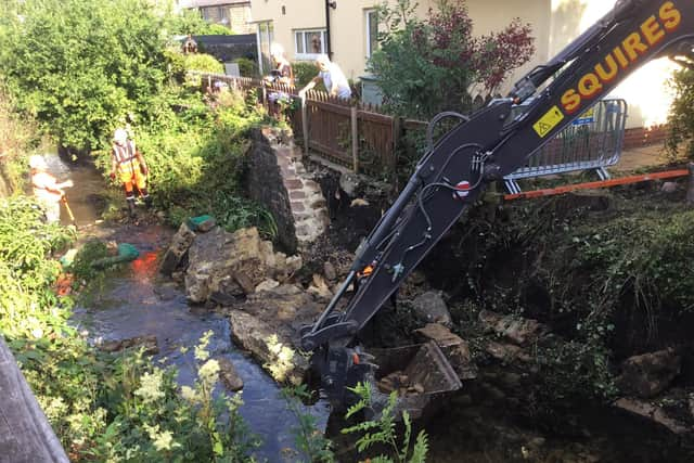
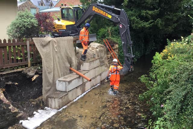
The announcement comes at the end of another week when the town has been clearing flood damage caused by intensive rainfall on Saturday, July 8, and a deluge of surface water affecting roads, homes and businesses in hillside and low-lying areas.
Concerns over surface water accumulation have been growing locally for several years, with many residents and political leaders calling for a rethink of planning policy and drainage infrastructure – particularly with regards to the hundreds of new homes slated for development on greenfield sites uphill of the town centre.
Advertisement
Hide AdAdvertisement
Hide AdWhile planning matters are decided by Derbyshire Dales District Council, the county council is the lead flood authority, leaving both with questions to answer.

At a county council meeting on Wednesday, July 12, Matlock representative Councillor Sue Burfoot, who is also a member of the district’s new Lib Dem-led administration, called on leader Barry Lewis to deliver more help to the town.
She said: “This was not limited to the town centre; residential properties were affected in various parts of the town, especially Matlock Bank, including a property immediately below the council’s own car park from which surface water run-off is not effectively contained.
“The Environment Agency have stated that they believe recent housing developments on greenfield sites have contributed to the alarming increase in flooding incidents over recent years and we know that the Bentley Brook pumping station at Matlock Green cannot cope with deluges which we now experience all too frequently.
Advertisement
Hide AdAdvertisement
Hide Ad“However, it is this council which is responsible for maintenance of highway infrastructure, which has been unable to control surface water run-off, leading to flooding and accumulation of water in the town centre. Surely, both our principal councils must share responsibility and implement policies to protect our local environment and communities from storm damage, by ensuring that proper infrastructure is in place to support both existing and new housing developments.”
She added: “Has the time come for our flood team and specialist consultants to fully assess the effects of climate change and the cumulative impact of so much new residential development, which is of course replicated in other communities throughout Derbyshire?”
The council has now confirmed that such an assessment has already begun – though it did not specify whether its scope would match what Councillor Burfoot had called for.
A spokesperson told the Derbyshire Times: “We recognise the importance of understanding why flash flooding is an issue in some parts of our county. We commissioned a major hydraulic modelling study earlier this year to look at the complex issues in Matlock town centre. The results of the study, likely to be published at the end of the year, will be used to identify potential solutions for the area.
Advertisement
Hide AdAdvertisement
Hide Ad“We are also working closely with a number of key partners, including the Environment Agency and Severn Trent Water, to develop ways to manage flooding across the Upper River Derwent region, stretching from Buxton to Matlock, including options like tree planting, creating natural dams made from logs across smaller streams to slow the flow of water and improvement works to existing flood assets.”

They added: “On Saturday night, we experienced significant heavy rainfall and thunderstorms across Derbyshire, following the very warm and humid weather conditions. Due to the steep hills around Matlock, the torrential rainfall collected and soon overwhelmed the drains in several locations, causing flash flooding.
“It would have been difficult for any drainage system to cope with the deluge we experienced, highlighting how the impact of climate change is causing more intense bursts of torrential rain in many areas.”
The county council has already demonstrated awareness of the potential problems caused by built development in Matlock, after lodging a formal objection to plans for more than 400 homes on the site known as the Wolds, north of the centre off Gritstone Road.
Advertisement
Hide AdAdvertisement
Hide AdThat objection was based on assessments from Severn Trent of the developer’s projections for surface water management.
Though the site is slated for development in the district council’s Local Plan, a planning application from the developer was submitted by the developer in 2018 and there has still been no decision from the district.
That means responsibility has passed from the planning committee convened by the previous Conservative regime to the new ‘progressive alliance’ which has said it wants to give communities a greater say over plans on their doorstep. It remains to be seen how much that could alter the outcome of an application already in progress.
In the meantime, Matlock residents have been taking to social media throughout the week sharing pictures of road surfaces damaged by flood, but the county council says its clean-up operations are on track.
Advertisement
Hide AdAdvertisement
Hide AdThe spokesperson said: “Our team were out in the evening, the next day and this week, replacing lifted manhole covers, patching sections of road which had been washed away and cleaning the drains to empty tree branches, leaves and gravel washed in to them following the thunderstorm.
“We have a thorough maintenance schedule to keep drains and gullies clear and free flowing in readiness for heavy downpours.”
They added: “The drains along the A615 Bakewell Road have been cleaned again following the surface water flooding, to remove debris washed in to the drains during the thunderstorm on Saturday evening.
“Earlier this year we reviewed our road network and recognised the importance of key routes like the A615 through Matlock, and as a consequence increased the cleaning frequency of the drains and gullies.”