
'Significant number of jobs' envisaged in advance manufacturing superhub proposal for industrial park on Derbyshire border
A proposal to build an advanced manufacturing superhub on an industrial park straddling the Derbyshire/Nottinghamshire border would bring a significant number of jobs to the area.
The plan for Explore Park, Steetley is disclosed in an Environmental Impact Assessment (EIA) Scoping Report prepared by DHA on behalf of Ebsworth Holding & Finance Ltd. Bolsover District Council has received the report as part of the EIA Scoping Opinion request process.
The report says of the proposed development of a 97.8 hectare site: “Construction of an advanced manufacturing superhub comprising the erection of buildings and associated service yards and plant for industrial and warehouse use and ancillary facilities including training, offices and research and development, open storage and logistics, together with associated infrastructure including, open space, roads, parking, drainage and landscaping.”
Creating a significant amount of employment space would result in a significant amount of jobs during construction and in the long term, says the report.
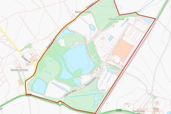

The proposed development areas are divided in five key zones occupying the northern east and southern areas of the site. Previous land uses have caused notable changes to the landscape fabric and as a result the site has capacity to accommodate large-scale development across the five zones without resulting in unacceptable impacts on the landscape character. The report states that the site was historically in use as agricultural land prior to the majority of the area being used for quarrying with infrastructure including a railway, tramways, limekilns, tanks, tunnel, brick works, gasometer, spoil heaps and ponds. After operations ceased, licensed landfilling took place to restore quarried areas. A mine shaft was present on-site, which is understood to have been treated.
The A619 runs along the southern edge of the site, connecting to the M1 at junction 30, approximately four miles west of the site. Steetley Lane, a narrow, winding country lane, runs along the western edge of the site. The eastern boundary is formed by the Robin Hood railway line and the area to the north is open countryside.
Access to the site will utilise the existing access from the roundabout on the A619. Internal access will be via the previously constructed spine road which all vehicles use to access Laing O’Rourke, the multi-national engineering and manufacturing-led construction company.
National Highways has recommended that the applicant undertake a Transport Assessment in a staged approach with the contents and methodology scoped out with National Highways and Nottinghamshire County Council in advance.
Derbyshire County Council in its role as Lead Local Flood Authority was requested to provide input to the EIA scope for this future application site. A senior technician in the authority’s flood management department wrote: “The County Council advises that the LLFA is not a statutory consultee in relation to EIAs and as such we recommend advice is sought from the Environment Agency in this respect.
“However, any future planning application for this site will require a Flood Risk Assessment as the site is over 1 ha (hectare), regardless of the need for a flooding/hydrology related chapter within the EIA.”
On behalf of the county council, the senior technician offered comprehensive advice on Sustainable Drainage Systems (SuDS) and surface water.