Huge list of temporary Traveller sites unveiled by local authority in Derbyshire
and live on Freeview channel 276
Derbyshire Dales District Council has failed in its legal obligations to provide sites for Gypsy and Traveller families for decades and has spent thousands of pounds in its search for suitable permanent plots.
However, after years of investigations it has found itself back at square one and is asking councillors to approve temporary approved plots on which to accommodate two Gypsy and Traveller families who have formally declared themselves as homeless.
Advertisement
Hide AdAdvertisement
Hide AdThe two families in question, who have long-standing connections to the Derbyshire Dales, are currently staying on the Clifton Road coach and car park in Ashbourne and the train station car park in Matlock.
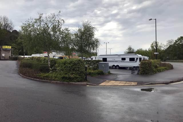

Those two sites are among 133 council-owned plots of land which are deemed to be large enough and potentially suitable to temporarily accommodate the two homeless families.
The temporary traveller sites would only be used for a short period of time, with the council previously suggesting a limit of eight weeks at proposed sites.
One of the families, who identify as Romany Gypsy, now staying on the Clifton Road car park site in Ashbourne, told the Local Democracy Reporting Service that they are tired of being moved from car park to car park and that these types of plots are unsuitable because they are too noisy.
Advertisement
Hide AdAdvertisement
Hide AdThis long list of potential sites includes 25 plots in Matlock, 21 in Bakewell, 17 in Ashbourne, 16 in Matlock Bath, 12 in Wirksworth and 11 in Darley Dale – with the majority being council car parks and others being empty plots of land or playing fields.
Among these sites are numerous plots which Gypsy and Traveller families have previously stayed at, including areas near the Agricultural Business Centre in Bakewell and the Old Station car park in Rowsley.
It also includes a plot of land at Knabhall Lane, Tansley, which until recently had been the council’s planned permanent Traveller site. However, it dropped these plans after 18 months of investigations due to it being a former landfill and because of protected badgers living on the site.
Council officials say a code of conduct would be drawn up by the authority which would lay out terms which Gypsy and Traveller families must abide by if they are to stay on the approved temporary site or sites.
Advertisement
Hide AdAdvertisement
Hide AdIf these rules are not followed the council would seek eviction action, it says.
These rules include leaving the site clean and tidy, to use provided toilet facilities, keep all animals under control and not to block the public highway.
They say that if toilet facilities are not provided, tenants must not relieve themselves in public view or leave toilet paper “lying around”.
The rules say that tenants must not engage in any anti-social behaviour or criminal activity, cause any damage to provided facilities or chop down or damage any trees.
Advertisement
Hide AdAdvertisement
Hide AdA council report on the issue, to be debated on Thursday, July 28, says: “Members are now asked to approve the use of one or more of these sites as identified temporary Traveller sites for the two Traveller families who have been accepted as homeless.
“This decision will relate only to members of the two homeless Traveller families and not to other members of the Gypsy and Traveller community.
“Officers will continue to manage any unauthorised encampments consisting of Travellers to whom the District Council does not have a homelessness duty by carrying out swift action to repossess any occupied land, in accordance with law.
“It is also recommended that Members consider those circumstances in which it would be reasonable to conclude that any identified temporary site might have become unsustainable, such that action to move the family occupying it to another identified site would be a reasonable course of action to take.
Advertisement
Hide AdAdvertisement
Hide Ad“These circumstances might include issues such as unacceptable anti-social behaviour, environmental impact, the welfare and social needs of the Travellers, justifiable complaints from nearby residents, and impact on the lawful use of the land.”
Here is the long list of potential temporary council-owned sites which could be selected for use by the two homeless Gypsy and Traveller families:
Auction Close car park, Ashbourne Bankcroft picnic area, Station Road, Ashbourne King Edward Street car park, Ashbourne Leisure Way car park, Ashbourne Clifton Road coach and car park, Ashbourne Recreation ground, Cokayne Avenue, Ashbourne Cokayne Avenue car park, Ashbourne Shawcroft car park, Park Road, Ashbourne Clifton Road park, Ashbourne Fish Pond Meadow car park, Ashbourne Land at Shawcroft, Ashbourne Fish Pond Meadow playing fields, Ashbourne Land at Blenheim Road, Ashbourne Land north-west of Greenway, Ashbourne Market Place car park, Ashbourne Land between 75 and 85 Brookside, Ashbourne Land north-west of Clifton Road, Ashbourne Monsal Head car park, Ashford Monsal Head overspill car park, Ashford Land east of Madge Hill, Atlow Land at Riverside Crescent, Bakewell Agricultural Business Centre, Agricultural Way, Bakewell Land at Station Road, Bakewell Bath Gardens, Rutland Square, Bakewell Land south of 59 Yeld Close, Bakewell Riverside Gardens, Bridge Street, Bakewell Land south of Bakewell Show Office, Agricultural Way, Bakewell Car park south of Bakewell Show Office in Agricultural Way, Bakewell Car park off Agricultural Way, Bakewell Land at the Showground, Agricultural Way, Bakewell Car park at the Showground, Agricultural Way, Bakewell A second car park at the Showground, Agricultural Way, Bakewell Rutland recreation ground, Haddon Road, Bakewell Land at Granby Croft car park, Granby Road, Bakewell Granby Croft car park, Granby Road, Bakewell Land at Market Place car park, Bakewell Market Street car park, Bakewell Land at Highfield Drive, Bakewell Land at car park off Agricultural Way, Bakewell Agricultural Way car park, Bakewell Land at Mill Street and Buxton Road, Bakewell Land at Nether End car park, Baslow Nether End car park, Baslow Bonsall Park, Yeoman Street, Bonsall Lime Yard, Mill Road, Cromford Land to the rear of 2-10 Rose End Avenue, Cromford Land north of the cemetery, Oakerthorpe Road, Bolehill Land north-west of the Arc Leisure Centre in Darley Dale Land between Columbell Way and Dale Road North, Darley Dale Broad Walk park, Darley Dale Land on the south side of Old Road, Darley Dale Land between Lime Grove and Dale Road North, Darley Dale Land on the east side of Bent Lane, Darley Dale Land on the west side of Newell Way, Darley Dale Arc Leisure Centre car parks in Morledge, Darley Dale Land off Morledge, Darley Dale Land on Crowstones Road, Oker Avenue, Darley Dale Land north-west of Pumping Station, BakewellRoad, Darley Dale Land at the Hawkhill Road car park, Eyam Hawkhill Road car park, Eyam Land in Croft Road, Edge View, Great Longstone Parsons Croft car park, Mill Lane, Hartington Oddfellows Road car park, Hathersage Land at Fell View Close, Hathersage Land at Oddfellows Road car park, Hathersage Ashes Avenue playing field, Hulland Ward Land at Weston Bank, Marston Montgomery Huntsbridge recreation ground, Alfreton Road, Matlock Lido car park, Matlock Public gardens, Smedley Street, Matlock Land on the east side of Cavendish Road, Matlock Long on the north side of Derwent Way, Matlock Land south of Asker Lane, Matlock Derwent Way car park, Matlock Derwent Avenue, Matlock Hall Leys Park, Causeway lane, Matlock Pic Tor, Dale Road, Matlock Starkholmes recreation ground, Starkholmes Road, Matlock Bank Road car park, Matlock Town Hall car park, Edgefold Road, Matlock Station car park, Derwent Way, Matlock Land to the rear of the old bus station, Imperial Road, Matlock Bus station, Bakewell Road, Matlock Denefields recreation ground, Lime Tree Road, Matlock High Tor, Dale Road, Matlock Playing fields to the rear of Baileys Mill, Lumsdale Road, Matlock Land between Tansley Wood Mill and Hurst Rise, Matlock Lane to the rear of 150 to 210 Hurst Rise, Matlock Land to the east of the bus station, Derwent Way, Matlock Land to the west of Pic Tor Lane, Matlock Cavendish Road recreation ground, Matlock Land opposite 180-204 Dale Road, Matlock Bath Station Yard, Dale Road, Matlock Bath Pavilion car park, South Parade, Matlock Bath Temple Walk car park, Matlock Bath Land at Temple Walk car park, Matlock Bath Station Yard car park, Dale Road, Matlock Bath Land at Station Yard car park, Dale Road, Matlock Bath A second plot of land at Station Yard car park, Dale Road, Matlock Bath Artist’s Corner car park, Matlock Bath Land at Artist’s Corner car park, Matlock Bath Lovers’ Walks, Dale Road, Matlock Bath Derwent Gardens, South Parade, Matlock Bath Land south of the River Derwent, Dale Road, Matlock Bath Land south of North Parade, Matlock Bath Land off Clifton Road, Matlock Bath Land on the west side of Dale Road, Matlock Bath Millenium Gardens, Stile Croft, Middleton Land north-west of the cemetery, New Road, Middleton A second plot of land north-west of the cemetery, New Road, Middleton The Peak Rail site in Harrison Way, Northwood Northwood recreation ground, The Avenue, Northwood Old Orchard car park, Over Haddon Land at Old Orchard car park, Over Haddon Old Station Close car park, Rowsley Land at Old Station Close car park, Rowsley Land to the rear of Edge View, Stoney Middleton Land west of Old Coach Road, Tansley Land south of Nottingham Road, Tansley Land at Knabhall Lane, Tansley Land at Leacroft Road, Winster Fanny Shaws playing fields, Cromford Road, Wirksworth Land adjacent to 26 Griggs Gardens, Wirksworth Land to the rear of 1-9 Steeple Grange, Wirksworth Canterbury Road car park, Wirksworth Land at The Dale car park, Wirksworth Yokecliffe Park, Yokecliffe Drive, Wirksworth Land south-east of Hopton Works, Middleton Road, Wirksworth Old Lane car park, Wirksworth Land to the west and east of Old Lane, Wirksworth Bolehill and Steeple Grange recreation ground, Wirksworth Barmote Croft car park, Chapel Lane, Wirksworth Gorsey Bank recreation ground, Wirksworth