Peak District landscape inspires geologist's new book


Dr Tony Waltham has published 20 books about geology and his documented travel diaries feature China, India, Tibet, Russia and Syria among his many explorations.
Tony's latest book - Peak District: Landscape and Geology - is inspired by an area just an hour's drive from his home. He said: "I'm big into caves and although I live in Nottingham, I was a caver in the Yorkshire Dales. Some ten years ago I wrote a book about the Yorkshire landscape and geology. Then the publisher said 'how about doing one on the Peak District?
Advertisement
Hide AdAdvertisement
Hide Ad"I've been to the Peak District hundreds of times and have been going there for years. Then suddenly we couldn't go anywhere because of the coronavirus pandemic so I wrote instead."
Tony, 78, who worked as a senior lecturer in engineering geology at Nottingham Trent University for almost 40 years, has used his own photos to illustrate the paperback book. In his book, he explains how the landscapes of limestone plateau, grit moors and river valleys of the Peak District evolved over millions of years. How the rocks that now form the terrains of the White Peak and the Dark Peak were laid down on the floors of tropical seas and deformed by plate tectonics before being shaped by streams and rivers. How the white limestone was fretted above hidden cave systems before generations of miners and farmers made their mark on the landscape.
The author also offers the best walks for people to see the landforms, including Lathkill Dale, Kinder Scout and Castleton.
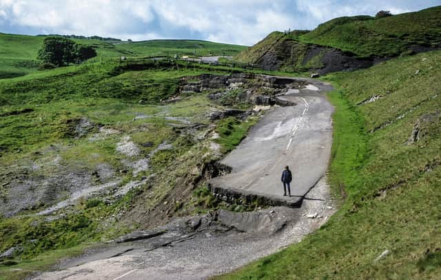
Tony said: "My favourite place would have to be Castleton because the geology there is wonderful and it's scenic. It's got great caves and it's also got the big Mam Tor landslide. The old main road through Castleton which used to be the trunk road across the Pennines ran across a landslide just above the village. A big new step in the road first appeared in 1976 and it's been moving ever since. The road has been closed permanently since 1977 because they can't keep up with patching it. Nowadays it's a popular tourist site.*
Peak District: Landscape and Geology is published by The Crowood Press, priced £16.99.